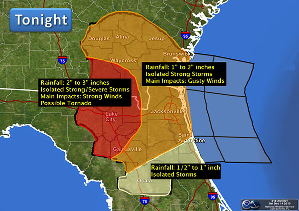
Widespread showers and isolated storms will push into inland Southeast Georgia and the Suwannee River Valley late this afternoon and will overspread the entire forecast area tonight. Rainfall totals will average 1 to 3 inches across the forecast area. Isolated strong to severe storms will be possible with damaging winds…mainly across the Suwannee River Valley. An isolated tornado cannot be completely ruled out, but the threat remains low. Please check out the graphic below for detailed impacts by location.

Northeast Florida and Southeast Georgia Impacts:
Tornadoes: The threat for isolated tornadoes remains low. However, if stronger thunderstorms are able to develop, the threat for tornadoes could increase very late this afternoon and evening…mainly over the Suwannee River Valley.
Winds: While the main threat from any thunderstorms that form will be gusty winds of 40-50 mph, the potential exists for a few stronger storms capable of higher wind speeds. Damaging straight line winds in excess of 58 MPH will be possible late this afternoon and evening…mainly across the Suwannee River Valley.
Rainfall: Rainfall amounts will average 1 to 3 inches…with the highest amounts across the Suwannee River Valley.
Marine Impacts: A Small Craft Advisory is in effect for the offshore coastal waters for strong south/southwest winds ahead of the frontal passage.
The National Weather Service will continue to monitor the progress of the approaching storm system and will provide updates as needed. Additional updates and further details on potential impacts will be emailed as staffing/time permits. Please reference the additional resources below for more information.
12-14-13
11:45 hrs
