
Tropical Disturbance will bring Widespread Heavy Rainfall through Wednesday
Synopsis & Timing
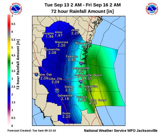
Low pressure currently moving onshore along the east central Florida coast will spread bands of heavy rainfall and embedded thunderstorms into the coastal counties of northeast Florida later this morning, with activity overspreading the rest of northeast Florida and southeast Georgia during the afternoon and evening hours. This system will provide a more significant impact to coastal locations than Hermine, with intense rainfall rates possible this afternoon and tonight that will increase urban and low-lying flood concerns. Downpours will continue to stream over our region through at least Wednesday, with widespread rainfall amounts of 2 to 4 inches forecast. Coastal locations may receive upwards of 4 to 6 inches of rainfall during this event. Strengthening onshore winds today will create a high risk of rip currents at area beaches, and small craft advisories are in effect for the coastal waters through Wednesday morning.
Flooding and Severe Weather Hazards
Coastal locations will experience a localized flood threat this evening through Wednesday, particularly during times of high tide when runoff is often blocked. High tide occurs along the Atlantic coast during the early evening hours tonight and again around sunrise on Wednesday. Wind gusts of 40-60 mph will be possible within heavier rain bands, and waterspouts will also be a near shore and coastal hazard during this event. An isolated tornado is also possible at inland locations this afternoon, and the Storm Prediction Center has placed our area within a marginal risk for severe thunderstorm development through this evening.
POSTED: 09-13-16 | 11:30 hrs